DLR-ISIS irradiances are derived through
radiative transfer calculations based on physical optical properties of
the atmosphere. Details of the radiative transfer model and the
atmospheric properties data sets are given below.
Radiative
transfer model
Radiative
transfer through the Earth's atmosphere is calculated as 1-dimensional
transport through a horizontally layered, plane-parallel atmosphere. The
two-stream approximation of the radiative transfer equation by Kylling et al. (1995) is used to derive the
spectrally integrated diffuse und direct irradiances at the surface.
Absorption of atmospheric gases is included with a 32-band
correlated-k method by Kato et al. (1999),
that covers the whole solar spectrum from 250 nm to 4300 nm.
Cloud
microphysics are included with two parametrizations for the optical
properties of cloud particles. For water clouds the parameterization of Hu et al. (1993) is used, which is based on
Mie-calculations of liquid water droplets. Ice clouds are included with
the parameterization of Yang et al. (2000)
and Key et al. (2002). The effective
radius of water and ice particles is set to 10 µm and 30 µm,
respectively.
The radiative
transfer algorithm and parameterizations are included in the radiative
transfer library libRadtran (Mayer and Kylling 2005). For the derivation
of the DLR-ISIS data set, a program was built around this library to
ensure the correct combination of atmospheric parameters, initiate
radiative transfer calculations and handle the results. Further details
on the procedure developed for DLR-ISIS can be found e.g. in Lohmann (2006b) (in German) or in Lohmann et al. (2006a) (English paper).
Cloud data
Radiative
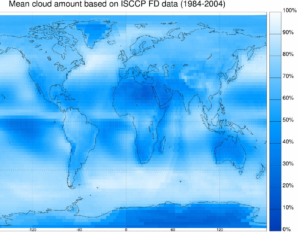
transfer calculations for the DLR-ISIS data set are based on ISCCP cloud data. The ISCCP
project currently covers the time span from July 1983 to December 2004.
Data from several geostationary and polar orbiting satellites are
collected and a consistent cloud product derived (Schiffer and Rossow 1983).
The cloud data used
for the derivation of the DLR-ISIS data set are taken from the ISCCP FD
input data set (Zhang et al. 2004), which
is based on ISCCP D1 cloud data (see ISCCP homepage for more
information about cloud data sets). It provides 3-hourly cloud
observations on a 280 km x 280 km equal area grid. The whole data set
consists of 6596 grid boxes on 72 latitude steps of 2.5°. This grid is maintained for the DLR-ISIS
data set.
ISCCP
differentiates between 15 cloud types. The classification includes three
intervals of optical thickness in three cloud levels: low, middle and
high clouds. Low and middle cloud types are further divided into water
and ice clouds, high clouds are always ice clouds.
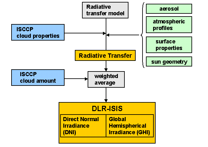
For DLR-ISIS, optical thickness, cloud top pressure and cloud phase
given in the ISCCP data set are processed to generate clouds for the
radiative transfer calculations. One radiative transfer calculation is
carried out for each occurring cloud type assuming 100% cloud coverage,
plus one calculation for clear sky. For the final result, irradiances
are weighted with the cloud amount for each cloud type and for
clear sky, respectively, and summed.

Other atmospheric data
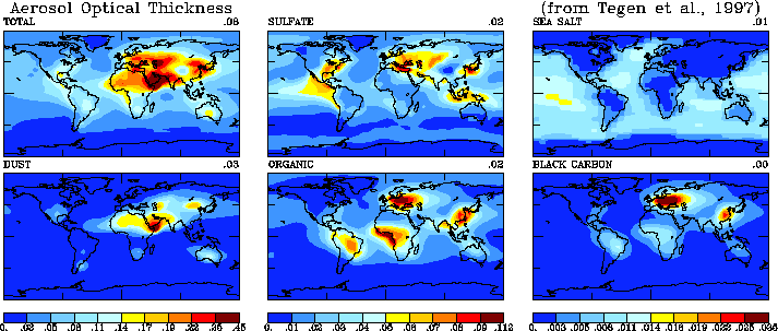
The input of the
aerosol optical thickness is split into two parts: tropospheric aerosol
and stratospheric aerosol. The optical thickness of the tropospheric
aerosol is taken from the NASA-GISS data set. This data set was
originally created for usage in the NASA-GISS climate simulations.
Optical properties of the most common aerosol types were measured by
various groups (Tegen et al. 1997). The distribution of aerosol types
was modelled with the help of emission data and transport models for the
dissemination of the aerosol particles. The results were combined in one
data set of 12 climatological monthly averages for optical thickness on
a 4° x 5° grid (Tegen et al. 1997).
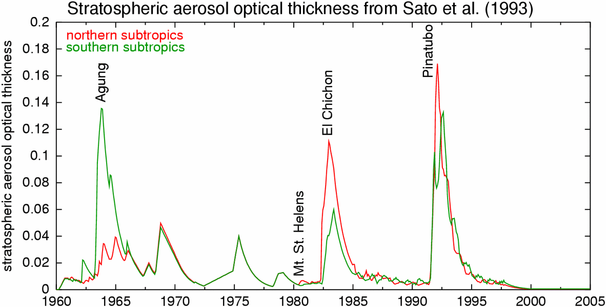
Stratospheric
aerosol is mostly caused by large volcanic eruptions. The data set used
for the derivation of the DLR-ISIS irradiance data is the Sato index (Sato et al. 1993).
This data set was also created for NASA-GISS climate simulations and
covers the time from 1850 to 1997. It consists of monthly averages of
optical thickness of the stratospheric aerosol in 7.5° latitude
bands. For the period coverd by the DLR-ISIS data set, it is based on
satellite observations of the Stratospheric Aerosol Monitor (SAM II) and
the Stratospheric Aerosol and Gas Experiment (SAGE I+II). Two major
volcanic eruptions affect the results of the DLR-ISIS data set: The
eruption of El Chichon (Mexico) in April 1982 and the eruption of
Pinatubo (Philippines) in June 1991. After 1997, an exponential decrease
was assumed until 2000 and no stratospheric aerosol has been included in
the radiative transfer calculations after 2000.


