THORPEX Pacific Asian Regional Campaign (T-PARC)
Overview | System | Campaign Diary | Gallery | Publications | Atsugi Schedule | Team | Links
THORPEX Pacific Asian Regional Campaign (T-PARC)Overview | System | Campaign Diary | Gallery | Publications | Atsugi Schedule | Team | Links |
|
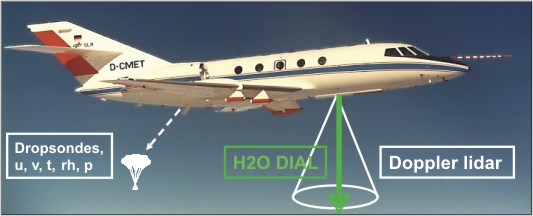
The DLR Falcon instrumentationThe observations will be performed by the DLR Falcon 20, call sign D-CMET. The instrumentation of the aircraft consists of a scanning 2-µm Doppler lidar for wind profiles, a 4-wave-length differential absorption lidar for water vapour profiles, a dropsonde system and in-situ sensors. |
|
|
|
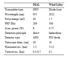
| Sketch of Falcon instrumentation and technical parameters of the lidar systems. | |
|
The new airborne DLR water vapour differential absorption lidar (DIAL) featuring four wavelengths (three online, one offline) for full troposphere coverage and a high power laser with high spectral purity was currently developed by DLR and was deployed for the first time in Summer 2007. This state-of-the-art system enables high spatial resolution humidity measurements with high precision. Wordlwide, this is the only airborne water vapour DIAL using four different wavelengths.
The airborne DLR Doppler wind lidar system measures wind profiles beneath the aircraft using the velocity-azimuth display technique. The instrument performs a conical scan around the vertical axis at 20° off nadir. The Doppler shift of the backscatter signal is proportional to the velocity component in the pointing direction from which the wind vectors are derived after one or more scanner revolutions. The scanning wind lidar yields profiles between 0.5 and 12 km altitude with an accuracy of better than 1 m/s at a horizontal resolution of 5 to 10 km. The vertical resolution of the measurements is 100 m. For the DIAL water vapour profiles from 0.5 to 12 km altitude with 10 % accuracy, the horizontal resolution will be between 1 and 5 km, and the vertical resolution between 300 and 500 m. Both lidar ranges are limited in the near and the far field: there are no data below 100 m AGL and in the 200 m (wind: 500 m) below flight altitude. Since all raw data are stored with high resolution, a trade-off between resolution and accuracy can be made when processing the data, depending on the scientific goals. |
|
|
|
|
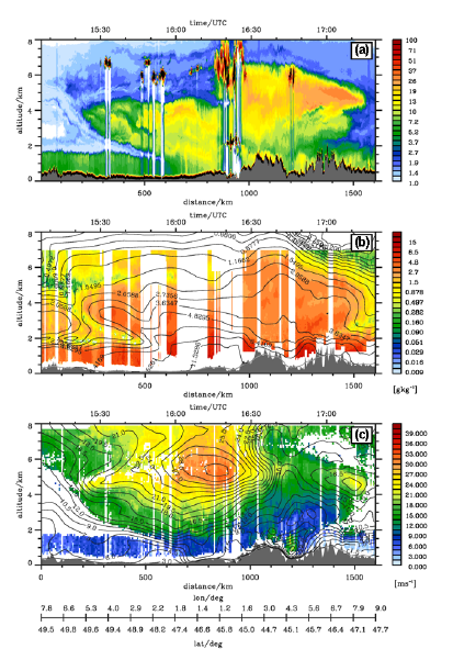
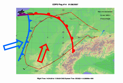
Example of lidar observations on a flight during COPS/E-TReC on 1 August 2007; (a) atmospheric backscatter ratio, (b)
specific humidity, and (c) horizontal wind speed, superimposed with contour lines of ECMWF short-term forecast data. The flight track over France and
south-western Germany is shown to the right. (Figure taken from master thesis of Andreas
Schaefler, 2008).
|
|
| Copyright © 2008 by Deutsches Zentrum für Luft- und Raumfahrt (DLR). Alle Rechte vorbehalten. |