XXVI OSTIV Congress30 July - 6 August 2003Leszno, Poland |
 |
|
|
|
Future of Meteorological Panel
After finishing the meteorological papers a small group discussed the future tasks of the
meteorological panel.
1. Brainstorming about specific questions:
What do we know about microturbulence? (in respect of microlights)
How to forecast severe turbulence?
What is the turbulence-spectrum to be considered for glider constructions?
What can be done with the logger files from (cross country) flights ?
What do we know about cloud streets and rolls ?
2. To increase and expand the members participating the Met-Panel-meetings more
internationally a meeting is planned USA parallel to the SSA-Convention in
Atlanta/February 2004.
Papers presented within the Meteorology Session
Summarized by Hermann Trimmel
- E. Lorenzen and O. Liechti: TopTask-Meteorological Flight Planning for Soaring
- Modern meteorological forecasts for gliding provide the diurnal evolution of convective lift
rates and the wind.. A technique named TopTask has been developed to establish flight
plans for individual flight tasks. Flight plans can be obtained for all types of soaring flight:
slow gliders with low glide ratio and wing loading - which are more sensitive to wind - may
be scheduled as well as fast gliders with high glide ratio and wing loading. Interactive pre-
flight optimisation of tasks is possible in real-time for all types of gliders and based on routine
forecasts. Analysis of recorded flight data and their comparison with the forecast
meteorological flight plan can be useful to meteorologists and pilots. Task setting for
individual and for contest flights can be substantially simplified by this new technique.

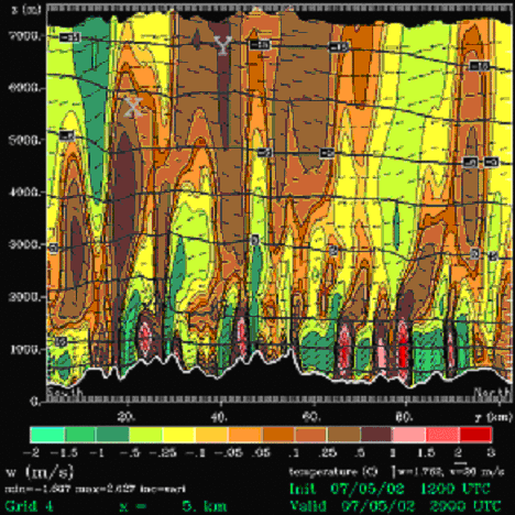
- W. Hindman, Ray McAnelly and Bill Cotton, Todd Pattist and Richard Worthington: An unusual high summertime wave flight
- One of the highest wave flights ever achieved over the Catskill Mountains of southern New
York State USA (17,990 ft or 5485 m MSL) was investigated. The flight was made by Todd
Pattist surprisingly on 5 July 2002 during the summertime when significant wave flights are
not expected. Extremely detailed, state-of-the-art computer simulations by Ray McAnelly
and Bill Cotton reproduced most features of the wave. Using the simulations, we showed the
flight could have gone to about 8,500 m MSL (almost as high as the summit of Mt. Everest)
had Pattist been prepared and had IFR clearance. This extraordinary mountain wave event
appears to have been enhanced by convective activity within the boundary layer above the
Catskill Mountains as explained by Richard Worthington. The success of the computer
simulations in reproducing the atmospheric conditions for this remarkable flight indicates the
computer model can be used to forecast wave conditions for other soaring flights.
Below are the results from the computer model that reproduce the location of Pattists'
highest climb (X) and the region where he could have climbed higher (Y):
- C. Lindemann, Germany: Thermal infrared Measurements- useful for glider pilots
- Where are thermals to be find an when do the finish ?
The temperature of the surface (soil) is important for the development of thermals. The
temperature can be detected by thermal infrared measurements(TIR) following the
Stefan-Boltzman-law.
1. Coniferes forests (especially clearings) have good properties for thermal development
but are relatively cold by TIR measurements. So the TIR values possibly detects the
cold forest soil, while the thermals develop from the forest tops.
2. Brown (with small vegetation) an yellow sandy soil have very different temperature
and thermal convection proportion. The brown surface (with vegetation) produces
better thermals than sandy soil which is an a good agreement with the TIR. The
reason is obviously the different albedo.
TIR-measurements can be used for seasonal and actual cross country planning for soil
with low vegetation. Forets must be dealt separately.
- Z. Aslan, Turkey: Modelling and classification of mountain waves
- Simulation and analysis of mountin waves in the troposphere are presented in this paper.
The shallow water theory was applied to investigate the fluid flows over an isolated hill.
This model gives a crude representation of atmospheric flow. Low level atmospheric
gravity waves (inertial waves) are also analysed by considering radiosonde observations
in Isparta (Turkey). Vertical variation of air temperature, relative humidity, horizontal wind
speed components and patterns that are associated with mountain wave observations
werde discussed.
- M. Dinges (presented by J. West): The total energy variometer in the flow field of thermals
- According to its physical working principle the TE variometer indicates additional signals
which are caused by inflow at lower and intermediate altitudes and outflow in the upper
part of a thermal. If there are inflow conditions the known procedures to displace a circle
towards the centre of the thermal are supported by the TE reading. However if there are
outflow conditions the maximum and the minimum of the vertical movement of air is not
correctly indicated. In this case it is recommended to initiate a displacement of the circle
upon a strong and continuous increase of the TE reading. If soaring conditions are good
circling at altitudes of the outflow should be avoided.
Impressum / Imprint - Datenschutzerklärung / Privacy Policy