Scientific and Technical Goals of AIRSPACE
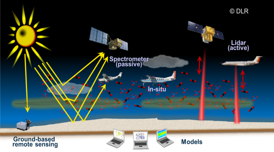
The overarching goal of the AIRSPACE project is to combine two complementing remote sensing techniques (active + passive) on aircraft to synergistically use their individual advantages for the measurement of the two most important greenhouse gases, CO2 and CH4.
Modelling is an equally important component of the project. The goal is to use the measurement results to determine regional scale fluxes of the GHGs by means of inverse modelling more precisely than possible today. To do so, results from chemistry-climate models on various scales are required and need to be linked to regional transport models. It will also be possible to validate the transport models using such independent, non-surface, atmospheric CO2 and CH4 measurements. By selectively using different data streams in a regional inversion, we will be able to assess the benefit from high-resolution measurement of the dry-air columns.
In the framework of this project the challenge is to realise an innovative scientific payload consisting of an imaging passive and an active remote sensing instrument, augmented by in-situ instrumentation on the German airborne research platform HALO. The payload has to be complemented by highly accurate in-situ instruments (for example also for isotope measurements) in order to achieve maximum synergy through adequate flight patterns that enable one to compare the remote to the in-situ sensors. Also ground-based remote sensing instruments (Fourier transform spectrometers) will help to characterise the airborne payload.
As an initial step towards meeting this challenge, a measurement campaign shall already be performed in the first part of the project for which a time slot has been reserved on HALO. On that aircraft, the CHARM-F lidar system together with in-situ instrumentation (cavity-ringdown spectrometer and flask sampler for isotope measurements) will be deployed, while the (passive) MAMAP system and other in-situ instruments will be installed on small aircraft (Cessna Grand Caravan and Cessna 207) performing co-ordinated measurements. This campaign (dubbed CoMet = CO2 and methane mission) has as its objective to collect scientific data about the CO2 and methane column to test the potential capabilities of the fully completed instrument combination. In order to support and validate these measurement, the most sophisticated in-situ instruments are required. Moreover, a model infrastructure (regional inverse modelling, chemistry-climate modelling with regional refinement) will be established in order to use the data streams of the individual instruments for modelling the greenhouse gas fluxes.
The two different model systems used will complement each other. STILT-TM3, operated by MPG-BGC, is a coupled regional Eulerian-Lagrangian model, which has been primarily developed to reduce transport errors in continental-scale top-down estimates of terrestrial greenhouse gas fluxes. It will be used for backward trajectory computations originating at the measurement sites to assess the source-receptor relationships, which are the basis for inverse flux estimates and source attributions. Using the WRF (Weather Research and Forecasting) model instead of ECMWF analyses will allow to operate this model in forecast mode for flight planning but also results in higher spatial resolution for a better interpretation of the atmospheric transport.
MECO(n) (“MESSy-fied ECHAM and COSMO models nested n-times”), operated by DLR, is the global chemistry-climate ECHAM/MESSy Atmospheric Chemistry model (EMAC) with a regional, multiple zooming capability based on the COSMO model of the German Weather Service (DWD). The on-line coupling of the different model instances allows for a frequent exchange of boundary conditions between the coarser (global or regional) and the next finer (regional) resolved model instances thus guaranteeing for a consistency between all relevant spatial scales. These unique strengths of MECO(n) will be exploited for the proposed project (1) to hind-cast the measurement campaigns on the regional scale, however consistently embedded into the global scale, (2) to assess the role of the different methane sources within and outside the campaign region, (3) to assess the chemical state of the atmosphere determining the photochemical lifetime of methane on both, the regional and the global scale, and (4) to simulate the isotopic composition (D, 13C) of methane on both, the global and the regional scale. Furthermore, a recently developed diagnostic technique to represent “emission (and age) classes” of methane will be used to complement the inversion based on WRF-STILT.
In brief, WRF-STILT will be used to directly invert the observations from the measurement campaigns (assuming a known methane sink) with the best estimate of atmospheric transport, and MECO(n) will be used to assess the corresponding aspects of atmospheric chemistry (sink processes). Both models ideally complement each other, because they have been built for different purposes and with different foci. This enables also the assessment of the uncertainties by comparing the results of both models.
As a secondary goal it is foreseen to validate the methane product of the satellite mission Sentinel-5P of the European Copernicus program whose expected launch will take place a few months before the campaign period. This exercise is targeted at proving the applicability of the methods to be developed also to future satellite missions (in particular the French-German climate mission MERLIN). This project part will also be accompanied by ground-based remote sensing instruments which will also provide another independent means to characterise the airborne payload during the campaign. Planned as the target areas for the co-ordinated measurement activities of HALO and the Cessna aircraft are Greater Berlin (to characterise urban emissions e.g. from traffic, sewage and waste disposal, gas leaks) as well as the hard coal mine areas of the Upper Silesian Basin (Poland).
Co-ordinated measurements in these areas will allow to better quantify those important sources by means of different independent methods but, in addition, these strong point sources also provide a unique opportunity to validate the new payload. The HALO surveys will extend the measurement area to wider regions than accessible with the smaller, low-flying aircraft.
In the further course of the project, a model environment will be developed for an analysis of the data collected which will help to devise new, synergistic methods for the combination of instruments. These will be investigated with respect to the quantification of greenhouse gas fluxes but also for validation of forthcoming satellite sensors. In the same time frame ground-based lidar measurements are foreseen to use the gap in between airborne campaigns to optimise and further characterise the performance of CHARM-F as well as to improve its evaluation algorithms. In parallel, the upgrade of MAMAP into an airborne, 2-dimensionally imaging spectrometer (MAMAP2D) system is foreseen. The emphasis of this activity will be, next to its realisation and test, the full characterisation and the development of the required algorithms.
The final result of the project will be the realisation of a scientific
payload for the HALO research aircraft together with adequate modelling
capacities which will enable the project alliance to significantly
contribute to large-scale international measurement campaigns potentially
focusing onto important target areas that are under-represented so far such
as the important source regions in the Arctic or Tropics.